
LandGlide: GPS Property Finder
Maps & NavigationProperty Lines Maps For Landowners Professionals.
Rating
4.3
Installs
1,000,000+
Price
Free
Screenshots
Ever found yourself wandering through the countryside, curious about who owns that sprawling field or charming little house you just passed? Well, if you're like me and love a good mystery wrapped in a property line, then buckle up because LandGlide is here to satisfy all your boundary-hopping curiosities!
Unwrapping the Magic of LandGlide
Picture this: you're on a road trip, the sun is setting, and you're surrounded by miles of idyllic land. Suddenly, you wonder, "Who owns this piece of paradise?" Enter LandGlide, the GPS property finder app that's like having a real estate agent in your pocket. Available on both Android and iOS, this app serves up a rich tapestry of property details right on your screen.
Features That Make You Go "Wow!"
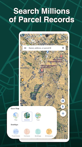
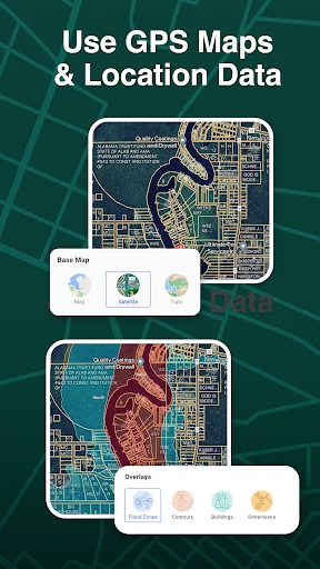
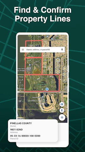
One of the coolest features of LandGlide is its ability to overlay property boundaries on a map using your device's GPS. As you move, LandGlide moves with you, updating the information in real-time. It's almost like magic, watching the lines pop up as you stroll or drive by.
Moreover, the app provides details like the property owner's name, the parcel number, and even the assessed value of the property. This can be a game-changer for real estate professionals or just curious explorers like myself who love knowing the lay of the land.
Why You’ll Love It
What I really appreciate about LandGlide is its user-friendly interface. Even if you're not a tech wizard, navigating through the app feels intuitive. The developers have clearly put a lot of thought into ensuring that users can access information with minimal hassle.
An added bonus is the offline mode. If you're venturing into an area with spotty internet service, no worries! You can download maps ahead of time and access all the juicy details offline.
A Few Things to Keep in Mind
While LandGlide is a fantastic tool, it’s worth noting that the app requires a subscription after a free trial period. This might not sit well with everyone, especially if you're just an occasional user. However, if you’re in the real estate business or frequently explore rural areas, it could be a worthy investment.
Another minor hiccup is that, depending on the area, some property data might not be as up-to-date as you'd hope. This isn’t a deal-breaker, but it’s something to be aware of if you're relying on it for critical decisions.
The Final Verdict
All in all, LandGlide is like having a secret key to unlock the mysteries of land ownership. It’s a nifty app that blends technology with curiosity in a way that’s both practical and fun. Whether you’re a real estate mogul in the making or just someone who’s always wondered “who owns that?”, LandGlide is worth checking out.
So, next time you’re out and about, give it a whirl. You might just find yourself hooked on the world of property discovery. Happy exploring!
Pros
- • High accuracy in property boundary detection.
- • User-friendly interface for easy navigation.
- • Offline mode available for remote areas.
- • Comprehensive property data included.
- • Regular updates with new features.
Cons
- • Requires subscription for full access.
- • Limited features in free version.
- • Battery drain due to GPS usage.
- • May lag in densely populated areas.
- • Dependent on mobile data for updates.
FAQ
What is LandGlide: GPS Property Finder?
LandGlide is an advanced GPS property mapping app that allows users to access parcel data, property boundaries, and ownership information. It is widely used by real estate professionals, land surveyors, and anyone interested in exploring property details. The app provides a seamless experience by integrating with GPS to offer real-time location tracking and data access.
How accurate is the parcel data provided by LandGlide?
LandGlide offers highly accurate parcel data sourced from a vast database that is regularly updated. However, the accuracy can vary depending on the area's data quality and update frequency. Users should cross-reference the information with official records for critical decisions, though LandGlide provides a reliable preliminary overview.
What platforms is LandGlide available on?
LandGlide is available for both Android and iOS devices, making it accessible to a wide range of users. The app can be downloaded from the Google Play Store for Android users and the Apple App Store for iOS users. It ensures a smooth user experience across different devices with its intuitive interface.
Is there a cost to use LandGlide?
LandGlide offers a free trial period during which users can explore its features and functionalities without any charge. After the trial period, a subscription is required to continue using the app. The subscription cost provides access to up-to-date property data and additional features, offering good value for frequent users.
Can I use LandGlide offline?
Yes, LandGlide can be used offline, which is beneficial for users in remote areas without internet access. The app allows users to save maps and data for offline use, ensuring they can access property information even when disconnected. This feature enhances its utility for fieldwork and outdoor exploration.